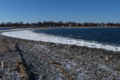
January 2013 has had a little bit of everything with the operative word being "little". We had a stretch of cold temperatures followed by a snap back to some moderate ones a bit above long-term averages. This led to a week or so of much above-average temperatures, and then a drop back towards a seasonal feel. The most notable stretch of the month we are now exiting placed us in the middle of a frigid polar air mass and negative temperature departures for several days. This stretch helped turn ponds, streams, and even some lakes and rivers to ice, shifting waterfowl across the area and sometimes putting birds like Common Mergansers in Long Island Sound instead of their favorite freshwater patch. Take a look at Stratford Point on one of those chilly days - that is nothing but ice accumulation due to the temperatures and the tide, and it helped keep waterfowl and shorebirds off our beach and out of feeding areas frequently.
Today we are going to be moving towards temperatures in the 40s before a powerful jump into the 50s on Wednesday. Immediately after that we'll experience a cold front with strong winds Wednesday night and then we will be back to winter. Despite all of that we are going to end up with a positive temperature departure once again for the month.
It has been a considerable time since I posted an examination of Connecticut's temperatures. I thought it would be a good idea to go back and take a look at all of 2012 from the official National Weather Service weather and climate monitoring stations in Bridgeport and Hartford.
2012 in Bridgeport:
January: +5.6
February: +6.3
March: +7.8
April: +3.6
May: +3.8
June: +1.0
July: +3.0
August: +2.3
September: +1.2
October: +3.2
November: -2.8
December: +4.2
2012 in Hartford:
January: +5.5
February: +6.0
March: +9.3
April: +2.5
May: +4.3
June: 0.0
July: +2.6
August: +2.2
September: +0.6
October: +3.4
November: -2.4
December: +3.7
At least our deviation from the norm decreased in the second half of the year as we did not surpass five degree differences again after doing so in January, February, and March. One can hope 2013 will have many more months with a degree or two above or below average. November was the first month with a negative departure in a considerable amount of time, going back many more months than shown above. If you take a look at the day-by-day temperatures of November only three days at each of the climate stations hit double-digit departures. What this tells us is that it was a very consistent pattern, and most of the days were just a little cooler than usual. If only we could have a month like this in the critical spring season instead of the somewhat meaningless month of November when wildlife across Connecticut is all but set for winter.
The interesting part of that November data is that it was the immediate aftermath of Hurricane Sandy, it being an enormous low pressure system that yanked a mass of seasonally cool air down upon us as it moved away at the end of October. This did not account for the entire month of weather or all of the temperatures, certainly, but one could almost say it took a historic hurricane to bring us some relief from the "heat" of the past few years.
Scott Kruitbosch
Conservation Technician
Photo by Scott Kruitbosch © Connecticut Audubon Society and not to be reproduced without explicit CAS permission
Blog Archive
-
▼
2013
(64)
-
▼
January
(36)
- Last One this Month
- Radio Silence
- Shawn Portmann and Pierce Bank
- Precipitation of the past year
- Temperatures of the past year
- Identify this waterfowl answer
- Something More Serious
- Roadkill app
- The Other World
- Common Man in 2013
- Hawks hunting feeder birds
- Chilllin'
- Gray ghost
- Incoming; Ahmad al Assir on the Slopes
- Peeling a Little Apple
- Sporting
- Identify this waterfowl
- Nothing Much
- Odd duck
- Men at Work
- Sledding
- Leader Ahmed Dogan Theatened with Gun
- Beautiful People
- Sheriffs' Say No to Feds on Proposed Gun Laws
- Redpolls pouring down
- Kick-Ass Housekeeper Part II
- It's All in the Head
- Hairy Woodpecker with yellow patches update
- New Pest in Town
- China Needs Clean Air- Well we all Do!
- Explain This to Me
- Unheimish
- Beirut on Ice
- 2296 Meters above Sea Level
- AIG Bits The Hand That Feeds
- Leading the way from Fiscal Cliffs
-
▼
January
(36)
