Pink Fire Pointer February 2013

For the Love of the Game


This just came off the court, Dennis Rodman and Kim Jong Un have just shared a relationship that will last a life time and all for the love of the game, basketball.  Rodman even mentioned to Kim Jong Un that you have a friend for life.  I don't even want to get into politics at this point but will stress that basketball might have just saved everybody's ass.

 Kim Jong Un is a big basketball fan and what better guy to relate to then colorful Dennis Rodman, Rodman and Kim sat side by side at an exhibition game in Pyongyang on Thursday, chatting as they watched players from North Korea and the U.S. play in mixed teams. Thursday's game in Pyongyang was played with a packed gymnasium ended in a 110-110 draw, with two Americans playing on each team alongside North Koreans. The teams consisted of VICE (responsible for photo, nice by the way) correspondent Ryan Duffy, Moose Weekes, Buckets Blakes, and Bull Bullard of the Harlem Globetrotters, and North Korea's "Dream Team," all of whom played their hearts out in what we have termed a "basketball diplomacy" mission.

Alright everybody just take this in,  for what we have just witnessed is we are all the same for we love something.  Instead of War like the politics impose through out the world how about basketball to settle differences and since this has started with Kim and Dennis they could help you pick your team and that is to play instead of pray.  Kim and Dennis you two have just showed the world in how to get along, you guys are are my hero.  Keep politics out bring on the game where the players are appreciated instead of hated.

This game in North Korea will air on HBO produced by VICE and thank you Kim Jong Un for having us,  I wish we all could have been there.

Here is a decent clip on all of this without the skepticism.

Video uploaded by U Tube user AssociatedPress


A clip of Dennis you might not of seen which really shines a light on this colorful man,  you'll feel what I mean.  You did a great job with that man Phil Jackson, thanks coach! Your work might have just saved our butts on this planet. 

To think the Bulls grabbed shooting guard Michael Jordan in 1984 and in 1989-90 where head coach Doug Collins was replaced by assistant Phil Jackson was more than the beginning of a championship team but a franchise that would leave the world with their jaws on the floor with the out come of the North Korean basketball game with Kim and Dennis. The hell with politics, let this be the lesson to being more humane than human.


Video uploaded by U Tube user OfficialHoophall


Release Hundreds of Illegal Aliens


From Governor Jan Brewer:

Dear Friends,

I’m appalled to learn the U.S. Department of Homeland Security has begun to release hundreds of illegal aliens from custody, the first of potentially thousands to soon be freed under the guise of federal budget cuts. This is pure political posturing and the height of absurdity given that the releases are being granted before the federal ‘sequestration’ cuts have even gone into effect.

This represents a return to exactly the kind of catch-and-release procedures that have long made a mockery of our country’s immigration system. The news is especially concerning when coupled with DHS’ acknowledgment that it may not be able to maintain operation of 34,000 immigration jail beds, as mandated by Congress.

Everyone knows the federal government must get a handle on spending, and it is well past time that the President begins working with Congress to find real budget solutions. But we cannot let public safety and the rule of law be collateral damage of the President’s failed leadership to pass a budget.

Please take a stand with me to show the President and the federal government that this is absurd and our nation deserves better protection over its citizens! It takes 2 minutes to make a donation of $30, $20, or even $10 by clicking here. Your support is the only way I can continue this fight.

If donating by check, please make it payable to "Jan PAC" and mail to Jan PAC, P.O. Box 3798, Phoenix, AZ 85030.

This is absolutely unacceptable.

Thank you for standing with me and supporting my fight!

My very best,

Jan Brewer


Video uploaded by U Tube user Massteaparty


Raptors heading north

It may be hard to believe with all of the snow still covering Connecticut and chilly temperatures dominating the landscape but raptors are on the move to the north already. This is usually a good time of year to spot some early falcons showing up again. I typically find an American Kestrel or a Merlin hunting the coastline at places like Stratford Point, Long Beach, Sikorsky Airport, or Milford Point. I have been unsuccessful when it comes to them thus far in 2013, perhaps because of everything from bad luck to that still white groundcover.

However, just watching the skies while at home late in the afternoon last week put the thought of migration in my mind as I spotted a Sharp-shinned Hawk flying over. Accipiters can spend the winter here in Connecticut, even some of the harsh ones, and are often be found by bird feeders. This bird was not a "local" though. How do I know that? It was acting like all of the migrants we see in the fall do, flying high in the sky hundreds of feet up. This action alone is exposing it to other potential raptors and passerines.

A much more typical sighting of a winter accipiter

Accipiters hunting or staking out a certain area aren't going to be soaring at high altitudes like large Red-tailed Hawks. Accipiters are built for zipping through the forest. It was also flying in a pattern to try to catch dying thermals after a sunny and relatively warm enough day with a southerly flow. It would rotate up and soar as best as it could, flap hard several times and then conserve as much energy as possible. It moved rapidly to the north-northeast and out of sight.

If you visit http://hawkcount.org/ you will see that a bunch of hawk watch sites are already conducting some "spring" monitoring. Most of them are concentrated to our south in Maryland, Pennsylvania, Virginia, and so forth, but sites closer to Connecticut will be up and running soon. Other species are already moving on to breeding activity here in Connecticut. As has been discussed a lot lately on the CT Birds list serv Red-shouldered Hawks have been very active from backyard feeding sightings to mating birds being discovered already. Unfortunately while we benefit from Connecticut's geography in the fall it hurts our potential raptor migration observations in the spring. There may not be a hotspot to visit but you can still see plenty even if you are watching the sky in your own yard.


Scott Kruitbosch
Conservation Technician

Photo by Scott Kruitbosch © Connecticut Audubon Society and not to be reproduced without explicit CAS permission
The only people on the beach: Dog owners and Dutch (is there a connection?)


It’s an odd contrast; last week I was up in the snow, this week I am at the beach. And I didn’t even have to travel for that; all in one country. But this is a land of contrasts, so it fits right in. 
The beach isn't ready yet; the boardwalks haven't been painted yet


A land of controversy indeed. Teachers strike during the week, but then force parents to send in their kids on Saturday to ‘make up’ for the missed days. Make up? Then what’s the point of the strike?

You cannot marry someone from another religion and keep your own religion & your rights at the same time; you’d both have to renounce your own religion first, and if you want to vote for members of parliament of a different religion then yours, you better become a jew; they’re the only ones allowed to.  But then again, we hardly have any jews left, we made sure of that, because we are so narrow-minded when it comes to other religions. 
My son ‘identifies’ himself with a certain sect in this country, and I am thinking ‘you twit, you've never set a foot in a mosque, the only time you've been to church was for a funeral, you don’t know how to pray in either religion; how can you identify yourself with any sect at all?
But I cannot blame him completely, because when a friend’s grandfather died, and he asked if he could come for the condolences, he was told, “Well, you might not feel at ease, our condolences are done the greek-orthodox way.” And I am thinking, 'well, that message is clear enough.'  


Picnic on the beach


How come this young generation, that did not live through a civil war, with atrocities played out on both sides, is more fanatic than my generation? 
We had this discussion at work today. I work with a very mixed group of people; all Lebanese backgrounds and religions are represented, and they are my generation. 
Their explanation was that during the war, they lived divided (most of the time). Christians lived with christians, muslims with muslims (we did not have that sunni-shia divide then), and one did not mix. But then when the war ended, and the dividing lines (such as the Green Line) slowly disappeared, they suddenly saw the ‘others’ and were mainly surprised with the fact that the ‘others’ were not that different at all. 
It was an eye-opener,” said one colleague.

Friends

The current generation can grow up with one other, not divided. Yet it seems they choose not to. So what is it that sets the tone for this generation? What makes them decide to be part of one, and not of a whole (country)? It is puzzling to me. 

Bees and flowers and electrical fields

I don't know about you but I have always wondered how some insects like butterflies and bees are able to find the plants and flowers they seek. We often hold views and beliefs that pertain much more to humanity than other species. Sometimes we instinctively think that cats and dogs can see what we do, the same types of colors and intensities, when their vision is far different in a multitude of ways. Many people believe the myth that if you touch a baby bird the mother or father will smell you on it and reject the nestling because we all seem to think that even though we have a relatively poor sense of smell that all other creatures have a powerful one. That would never be a problem with an American Robin in your backyard - in reality the greater problem would be you leading mammalian predators, that do use their powerful sense of smell, to the nest.

But back to the bugs and specifically the bees, how do they possibly move around enough and have sufficient time to find all of the specific flowers they want to pollinate? It boggles my mind, but thankfully researchers at Bristol University's school of Biological Sciences have found some answers. Professor Daniel Robert and his team found, "patterns of electrical signals that can communicate information to the insect pollinator" and that "[t]hese electrical signals can work in concert with the flower’s other attractive signals and enhance floral advertising power." The press release continues saying:

"Plants are usually charged negatively and emit weak electric fields. On their side, bees acquire a positive charge as they fly through the air. No spark is produced as a charged bee approaches a charged flower, but a small electric force builds up that can potentially convey information. By placing electrodes in the stems of petunias, the researchers showed that when a bee lands, the flower’s potential changes and remains so for several minutes. Could this be a way by which flowers tell bees another bee has recently been visiting? 
To their surprise, the researchers discovered that bumblebees can detect and distinguish between different floral electric fields. Also, the researchers found that when bees were given a learning test, they were faster at learning the difference between two colours when electric signals were also available. How then do bees detect electric fields? This is not yet known, although the researchers speculate that hairy bumblebees bristle up under the electrostatic force, just like one’s hair in front of an old television screen."

There is so much going on around us that we have absolutely no awareness of because all life on Earth has a literally different perception of the planet than we do. We simply do not discern the same things. Birds are known to use magnetic fields and variations within it in order to navigate their way through the darkness during migration as they make their own map in their brains. This is just another level we have no sensation of and are not evolved to be tuned into. It makes you wonder how many more parts of our universe we are not seeing or how many dimensions there are to the cosmos beyond our planet. The more we discover about our natural world the more I believe what we feel is supernatural or science fiction is a lot closer to reality than we think.


Scott Kruitbosch
Conservation Technician

Good Morning, Sunshine

I wake up to a lovely sun rise; summer is in time. And while the city is still asleep, I see we have our very first visitors of the day.
 
Gooooood Mooooorningggg Beeeiiiirruuuuuuuuttttttt!!!!
Nobody circles Beirut like the Israelis do; always in pairs. UN security council resolution 1701, passed following the 2006 Israel-Lebanon war, forbids Israeli planes from flying over Lebanon. But what is a UN security council resolution to an Israeli? They violate Lebanese space on an almost daily basis. ‘Andrea Tenenti, a spokesman for the UN forces in Lebanon, Unifil, confirmed that Israeli forces had continued to violate Lebanese airspace, but said this was routine.’ (source) And after all, aren’t we terrorists? So it’s okay.

Connecticut State of the Birds 2013

Great-crested Flycatcher. Photo by Sandee Harraden
Our Connecticut State of the Birds 2013 report, “The Seventh Habitat and the Decline of Our Aerial Insectivores,” delves into the mysterious population decline of 17 species of birds that nest in Connecticut and rely on a diet of insects caught on the wing.

Released Friday, the report identifies pesticides as a possible cause of the decline: pesticides kill the bugs that aerial insectivores eat, and so it’s likely that a reduction in the use of these poisons will help the aerial insectivores.

We’ll be in Hartford on Monday testifying before the General Assembly’s Environment Committee in support of two bills that would lead to pesticide reductions in Connecticut.
You can read the news release about Connecticut State of the Birds 2013 on our website, here.

You’ll also find a link to the report itself and to excerpts from each of the articles (along with a list of authors).

The news release also includes a link to a video of the news conference, and we’ve provided links to news coverage of the event.


-- Tom Andersen, director of communications and community outreach

Really Really Bad?


My daughter’s field trip got cancelled. Much to her chagrin, as she had packed her bags already a week in advance. “Due to the current situation in Lebanon and the location of our destination, it has been decided that it will be best not to take the students,” the note from school reads.

It's been raining in Beirut

Due to the current situation?” I ask my hubbie, “What situation?” Deng, I am thinking, I should listen to the news more often.
The situation is bad, Siets,” he replies.
Really bad? Did anything happen?
Well, the situation is not very good. It’s bad.”
So nothing happened?”
Well, not specifically, but the situation is really bad.”
You said that two month ago as well.
Yes, but now is worse. It is really really bad.

Really bad? Like really really bad, because it was already really bad two months ago, and then it was worse than two months before that, when you said it was really really bad, and that time was also worse than the time before that, I am thinking. He’s been saying the situation is bad since 2005, and it’s gotten increasingly bad ever since, so I am wondering, how much more ‘really bad’ can we go?

Still raining . . . 
I don’t have time for this nonsense. Life is infinitely brighter when you do not watch the news.

Milford and Stratford Point bird lists on eBird

Have you ever wondered about the species that occur in the mouth of the Housatonic River, from Stratford Point east to Short Beach and to the Connecticut Audubon Society Coastal Center at Milford Point? Do you want to know what time of year a certain bird is present?  Would you like to see a dynamic listing of the birds we see? Do you want to help and contribute some of your sightings? Thanks to eBird you can now do this very easily. Your first step is to visit http://www.ebird.org where you should sign up for an account if you have not. Next navigate to the "Explore Data" tab on the top of the screen.

From there click on the second option from the top of the left side of the page, "Bar Charts". Our region, the United States, should already be selected. Then you can choose Connecticut out of the list below this.  Click on the bubble to the right for "Important Bird Areas in Connecticut" and then scroll down to the bottom and hit "Continue". You will then get a list of the IBAs in the state, and the one you will be looking for is "Milford Point/Wheeler Marsh/Mouth of the Housatonic River". Selecting this and hitting "Continue" again will lead you to a page with a bar chart of bird observations from all that have been submitted publicly to the database for areas like Milford Point, the Wheeler Marsh, Short Beach, Stratford Point, and so forth.

If you have entered data for one of these locations and it is a "hot spot" or even your own location that you have not made private and have mapped correctly within the boundaries of the IBA then your sightings should show up in the chart. At the time of this entry I see we have 300 species and 30 taxa displayed. That is a strong total but it still is far from the true number as historical rarities and occasional oddities still have yet to be added. Milford Point alone has over 320 species on its list. Nevertheless, some long-staying mega rarities like the state-first White-tailed Kite were recorded very well.  It even shows others like the Chuck-will's-widow I found at Stratford Point last May that stuck around for just one night.

This easy to find and read chart shows the potential and power of eBird as it captures information from dozens and dozens of birders at multiple locations within this critically significant region. The next time you visit the CAS Coastal Center at Milford Point or the CAS managed Stratford Point please consider entering the birds you find into eBird if you are not already.


Scott Kruitbosch
Conservation Technician

New Orleans Pelicans

On Tuesday night I was enjoying watching the National Basketball Association in action with my team, the Chicago Bulls, visiting the New Orleans Hornets. In the past I have written some about how often nearly all of the major sports leagues incorporate birds into their leagues and teams. Sometimes the names are obvious and extremely representative of a certain area (Major League Baseball's Baltimore Orioles) and other times they are a little more arbitrary (the National Football League's Atlanta Falcons). The New Orleans Hornets were originally the Charlotte Hornets, joining the NBA in the late 1980s. After moving to New Orleans in 2002 they were forced to Oklahoma City in 2005 for two seasons because of the damage wrought by Hurricane Katrina. They continued in the city and last year they were sold by the NBA to Tom Benson, also the owner of the NFL's New Orleans Saints. Mr. Benson is from New Orleans and has a keen understanding of the area and its history.

All of this was important in January's announcement that the New Orleans Hornets would be changing their name to the New Orleans Pelicans at the conclusion of the current NBA season. I was pleased to see another avian name going up in the NBA and naturally thought it was appropriate for the area. The New Orleans Pelicans has been used as a name for baseball teams of various levels in the past and the state bird of Louisiana is the Brown Pelican as well. Fans that were unsure or doubtful about the name were convinced by the amazing logo which looks true to life as well.


I was subsequently astounded to learn that Mr. Benson and the organization had a much deeper mindset when it came to using the Brown Pelican as it not only, "represent[ed] the culture and resolve of the Gulf Coast region" but "also symboliz[ed] Louisiana’s most pressing initiative of coastal restoration and wildlife conservation.The press release continues:

"The team’s cornerstone community platforms will focus on two initiatives critical to the future success and prosperity of the Gulf South Region; the health and sustainability of our coastal wetlands and the health and fitness of our region’s children. The message of a healthy habitat, in which the Pelican thrives, will provide the centerpiece for a program of healthy living, exercise and education to that of protecting, saving and restoring our coastal wetlands and wildlife. The Pelican will serve as that symbol. 
Perseverance and renewal have been hallmarks of our community’s resurgence and the Pelican’s remarkable recovery closely matches that of the Gulf South Region. The Pelicans will be more than a namesake for the franchise, as New Orleans, the State of Louisiana and the Gulf South have a rich history connected to the name. Represented on Louisiana’s state flag and seal, the Pelican has been the state bird for over a century. The Pelican symbolizes the determination to not only survive, but thrive even when the odds are stacked against them as our region has demonstrated over and over. 
“When we purchased the basketball team, it was a priority to change the name to reflect our culture, our community and our resolve. The Pelican does that,” said Owner Tom Benson. “Our region has been hard hit in recent years and the one thing that stands out is the resiliency and determination to comeback, to fight and overcome. The Pelican symbolizes that. The synergy of this name, this bird and the future of our state and region are intertwined and in three, five, ten years from now, it will be not only be a name of a sports franchise but it will also be the face of the continued recovery of our region. We will promote healthy habitats, not only for our youth but for our community, our coast and our wildlife. The Pelican name will do that. It is more than a name. It represents our way of life.”

I think it is a marvelous decision and one that should be applauded by everyone in the conservation community, especially those people who are not fans of the sport.  There is an enormous opportunity here to continue this sentiment with other teams in the future and to create this synergy where it doesn't yet exist with some of the other wildlife-related franchises across the four major sports. I hope the New Orleans Pelicans can draw enough fans each season to continue in the city for decades and that the organization will support these progressive words with aggressive action for the environment. You can check out even more on the name, logo, and colors here.


Scott Kruitbosch
Conservation Technician

Blizzard of 2013 Part III

After I posted all of the details on how well some of our weather forecasting and analysis tools functioned before and during the Blizzard of 2013 I decided I should post about some of the systemic failures when it comes to American weather as well. It's only fair to mention some of the gaps we have in meteorological science in this country as they are extremely relevant to conservation issues. Apart from public health and safety, being able to understand, predict, measure, and record our weather is important in monitoring climate change, from temperatures to tides, the impact of increasingly severe storms in the northeast, and to analyze in concert with data on our flora and fauna. All of the Connecticut Audubon Society Conservation and Management Plans include details on climate and weather for the specific areas being reported on to foster better understanding of what has occurred and what should be anticipated for the environment of a given region.

There is a misconception in the United States that we have various commercial entities to provide us with all of the weather data and information that is needed. Some ignorant politicians have even said in the past few years that we should get rid of the National Weather Service - we can just turn on The Weather Channel after all, right? The problem behind that theory is that The Weather Channel and every other weather entity uses all of the data that we fund as taxpayers. Those are our radar towers, our computer models, our weather balloons, our servers, our monitoring stations, and our employees providing all of this information that they simply dissect and analyze for your information (and increasingly for your entertainment). In many cases we have government employees doing the analysis part as well and often far better than those you find on television because they are focused on nothing except getting the forecast correct for the region they work in every day. It is absolutely vital that we fund such essential systems in order to keep our country functional on the most basic levels. It saves thousands upon thousands of lives every year as well.

The leader of the National Weather Service's Southern region was recently fired for allegedly legitimate reasons that seem a little suspicious as you can read in this Washington Post article. William Proenza had planned to limit radar usage on sunny and calm days in order to cover budget gaps and it seems the NWS did not particularly care for that idea. The piece highlights the $85 billion cut the NWS is going to be hit with. In my opinion, considering the cost of cleaning up after the parade of historic storms that has hit this country in the last decade (not to mention all of the lives lost and countless saved) it seems impractical to make such drastic cuts even in this financial climate.

Apart from not cutting technology coverage, employees, or services, the NWS could really use an upgrade and expansion in many areas. The Automated Surface Observing System (ASOS) is the primary method we use to record climate data, and while these stations are useful, they are severely limited during extreme weather conditions. They failed repeatedly during the Blizzard of 2013 whether it was frozen instrumentation falsifying wind speeds (at many places but even Boston's Logan Airport hitting around "100MPH") or stations recording incorrect basic observations (light snow and freezing fog during the true blizzard conditions at the one at Sikorsky Memorial Airport in Stratford). When it fails this regularly what are we supposed to use as baseline data? I am sorry to say much of what is recorded by the ASOS is highly suspect to me. While we can weed out the obvious mistakes they make what we miss while these errors are occurring is the real data we need.

Another tremendous failing is some of our modeling as the American computers, like the Global Forecasting System (GFS), cannot compare to the famed European model. This is not an arbitrary or subjective statement as you can see by looking at the graphs of Numerical Weather Prediction Model Verification here presented by Environment Canada. The ECMWF leads the way as usual with the ETA (North American Model or NAM) sticking out like a sore thumb in the worst way possible. Just days ago on The Weather Channel Meteorologists Chris Warren and Jim Cantore discussed the failings of the GFS and how much we rely on the Euro to correctly forecast the weather for our nation over our own products as the GFS failed once again with another storm on the east coast.


As they mention we will hopefully move in a better direction in terms of modeling soon with changes in leadership and new directives. My last and most maddening point brings us back to the Blizzard of 2013 and depicts both the internal struggle that occurs within the National Weather Service and some of the antiquated methods and systems we have in place in America. The Northeast Snowfall Impact Scale was created by Paul Kocin and Louis Uccellini and presented in Northeast Snowstorms in 2004 in order to ascertain the effect a system had on the nation and its people as it utilizes population and area to gauge and rank snowstorms. This is all well and good but take a look at this NOAA map and tell me what's wrong with it.


No, those numbers are not off by 10 each - this is the real map! The one red dot of 30 inches in Connecticut is centered on KBDR (Bridgeport's climate station which is actually in Stratford at the Sikorsky Memorial Airport but is measured by an individual who is a few miles north of Long Island Sound - how utterly ridiculous is that in itself?) as apparently none of the state received over 30 inches of snow. We all know this is not true, but for "official" purposes thanks to the lack of stations in the area, poor measurements, and too few resources, we end up with this atrocity. Look, I am all for standards and practices that need to be repeated through time and completely comprehend why we cannot take random numbers people measure and send in then put them as official data forever into eternity, but I am also for accuracy. This is far from the historical representation we need, and if our system works this poorly, it is time for a tremendous change.
On the other hand Brandon Vincent of NWS Raleigh, North Carolina, put out this unofficial storm total snowfall accumulation map which fits in closely with the reality we had in Connecticut.


Thank you, Brandon, for helping to keep a little sanity in the weather archives of the NWS. I hope the past few years of difficult and severe weather helps to spur some meaningful change in America's stagnant and often archaic meteorological bureaucracy and we can avoid harming it further.


Scott Kruitbosch
Conservation Technician

A Lesson for Future Brides (in Lebanon)

I spent the weekend in the Cedars. 

The ski slope in the Cedars (with the emphasis on 'THE'). The forest is in the distance, right side.

For those unfamiliar with Lebanon, the Cedars is a place up way up north , in the mountains, where the last remaining bits of the original cedar forest can be found; a forest that apparently once blanketed all the upper regions of Lebanon. 
Once’ is a loooong time ago; cedar wood was already in high demand way back when the Egyptian pharaohs build their temples in the Nile Valley, and when King Salomon constructed his templein Jerusalem. Heck, even Gilgamesh, some 7,000 years ago, knew where to get his wood. As such, 'forest' is only a relative concept;  there are some 300 trees left in this particular spot.


I'm zooming in on the forest

A friend of mine, new to the country, recounted her visit to the forest for the first time. All the way, from Beirut to the Cedars, and that’s some 120 kilometer, she was hearing about this ‘forest’. And coming from Holland, a forest is defined as a vast region full of trees. And so, after a very long drive over little narrow country roads that slowly snake their way up, she turns around this corner and sees this . . . . this park filled with some trees. “I came all the way for this?” she remembers saying. 

And it is true, if you want to see an impressive Cedar forest, the Barouk one is a bigger one, and the one near Hadeth el Jibbe more authentic. But still, the Cedar forest in the north is a regular stop for tourists.


And here it is. Quite impressive in the snow.
And in winter you go there to ski. ‘Skiing’ is also a relative term up there, it seems. Lifts open en slopes get groomed only if there are enough people to make it profitable for the family operating the hill (yes, it is only one hill), and if they feel like it. As such, opening and closing times are changeable, and availability of lifts and slopes equally unpredictable. You’d think at least the prices of their services would be competitive, but no, that is not the case either. 

A Dutch/Lebanese melange with some hints from Asia as well

This could be a post about how not to run a ski resort, but this rather homely style of running a business make the place a little rustic and endearing, and so we’ll keep it as it.

Instead, I’d like to talk about the self-assessment of Lebanese men. 
I was with a group of Dutch/Lebanese couples. In this case, most of the Dutch are women, and the men Lebanese. Any married woman can tell you that getting married is easy; it’s staying married that is the tricky part. Most definitely when it concerns a Lebanese man, as the cultural differences are not insignificant.


Some of the offspring of Lebanese/Dutch connections, with some real Dutch in there too, and hints of Tunisia and Vietnam (someone at work today called the Dutch 'swamp Germans'  I thought that was quite funny) 

Now most of us have managed to circumvent the major problems, and have arrived at a relatively satisfying status-quo.

One of us, however, is about to embark on this journey; She is going to marry a Lebanese man. Her own dad was Lebanese, so she is not totally unfamiliar with the species, but still, what is in store for her? What advise could we give her? What does it take to make it work? This particular conversation generated such incredible laughter and noise level that the other hotel guests, one by one, vacated the premises. Lebanese men – for the uninitiated – come with a manual thicker than what you get when you buy a 3D flat-screen TV.

Ah, and finally, the patient Dutch ladies. Samaritans we are :) 

But the interesting part came when the (Lebanese) men got their turn. 

And there were two things they brought up, I thought were of particular interest. 

The first one was that each and every one of them said that (even after being married to a Dutch woman, go figure!) they would never ever marry Lebanese women, for ‘they could not be trusted.’ “Sly bitches,” was the term one of them used, if I remember correctly. (Sorry ladies, I am just quoting.)  

Why Samaritans, you ask? Ah, if only you knew the story behind these feet . . . . 

And the second interesting bit of advice they gave the future bride was, “Don’t let him walk all over you.”  Their general message was, be strong, stay independent, don’t be his door mat, and show him right from day one that you cannot be taken for granted, otherwise he will take advantage of you, and treat you like you are his maid. What an insightful self-assessment that was!


When in the snow, build a snow man

The bride-to-be thought it all sounded rather negative. Of course, she is still madly in love and her hubbie-to-be is still the knight in shining armor, and she’s talking to a bunch of old-timers; we’ve each clocked some 20 years or more in marital positions.  And so this mixed Lebanese/Dutch crowd of pros smiled at her endearingly, and said in unison: "We’ll talk in a few years time.” 

The result

This dude of hers is so not going to thank us for this! And we had a good time. With our Lebanese counterparts. Despite? Or thanks to? I leave that up to you to decide . . . . ;)  But the mix sure makes for beautiful kids. If I may say so myself.

And that's me (thankfully unrecognizable), stolen from Mai (thank you Mai) 


Snow-covered Connecticut

The last week has been a difficult one at best for all of our birds that rely upon being able to see the ground or access low vegetation in order to feed. With three feet of snow and areas where drifts are three times that depth it can be a struggle to forage sufficiently. Take a look at the snow depth immediately following the storm on the NOAA map below.


If we ignore where it is inaccurate (Where is the band across Connecticut? Ugh!) it still shows us a lot of snow for the area compared to what it should be. Here is a map of the snow depth as of the current day.


There has been some improvement in depth, but this snowpack is here to stay for a while longer. One of the groups of birds we often think of quickly in such situations is sparrows. These birds are literally designed to feed on the ground with their drab shades of brown. Dark-eyed Juncos, White-throated Sparrows, American Tree Sparrows, and Song Sparrows are all common feeder birds that really had to work in the past week to find food or move quickly to more suitable habitat. Other more uncommon wintering sparrows that had similar problems include Savannah, Fox, Chipping, White-crowned, and Vesper. The first four are occasionally seen in yards while the rare last one has been recorded utilizing any available patch they could sometimes in sizable numbers (in relative terms) of several birds together.

Vesper Sparrows and many of the above species are often found using the edges of lawns, roadways, and fields that have been plowed along, exposing some of the earth. If you check roadsides (maybe not while actually driving) where you can see dirt you should keep in mind that it is likely a good spot to keep an eye on for something out of the ordinary. These exposed spots also bring in birds like the American Pipit, Snow Bunting, or Horned Lark. Stratford Point has had many Snow Buntings and Horned Larks ever since the storm because of the strong winds that contoured and displaced the snow on the exposed site. Between the gusts, subsequent warm days and bright sunshine on the coastal grasslands large areas of the ground are now free of snow. This Horned Lark was alone but cooperative as it fed along the driveway and nearby open lawn.


You can see the snow in the background of the image. This is also why it is important to leave some areas of what we would consider lawn or grass a little weedy and uncut heading into the fall season. If you have enough of these rough spots they may end up benefiting wildlife in dire circumstances. If Stratford Point was nothing but a mowed lawn we would little vegetation of any use to wintering birds. The property has enough open space that it can still serve Northern Harriers and mammal-hunting raptors as well. I have not seen a Short-eared Owl since the storm but I would imagine it is very inviting to one. I searched through the grasslands for more rare winter species like the Eastern Meadowlark but came up empty. I am sure there are a few surprises lurking in the area and in open patches of earth near you, too.


Scott Kruitbosch
Conservation Technician

Photo by Scott Kruitbosch © Connecticut Audubon Society and not to be reproduced without explicit CAS permission

Could The Mayan Clock be Off?


Well we skated on the 21st of Dec. 2012 on the Mayan predictions but when looking around the world today might the Mayan clock be off?  My meaning here is like someone has opened up Pandora's box,  a can of Whoop Ass has been pounding on many countries across the globe and no one is skating.  The ground shacking all over the place,  people wadding in neck deep water and extreme temperatures from -50 degrees Fahrenheit in Siberia to a sweltering 130 that was recorded in Australia.  The weather team down there had to reconfigure the color code of temps depicted on the weather map,  that's a first you do not want to experience. Yep the climate is changing but to what degree?  Records are being broken since we been recording them but in comparison to what we've been accustom to we're not in Kansas any more Toto.

Some extreme weather records

This is changing the way we're going to live on the planet.  Moving to higher ground, getting away from fault lines, away from parched land that burns with just a lighting stick that consumes 100 of thousands acres and storms that are whipping up the deadliest tornado's and hurricanes we have ever seen.  Just one of our oldest weather records dates out at 1820, that's only 193 years.  Think of the climate changes the planet has gone through in the pass 4.5 billion years,  ah that would be more than the years we have been keeping records.  So this is going take some getting use to,  until she settles down.  Unlike a meteorite which just hit Russia or polar shifts are abrupt changes,  man I don't know how we would adjust to that.  Survival of the fittest I guess as it keeps coming and brother it's here.

Video uploaded by U Tube user fidockave213


FIRE AND ICE

Video uploaded by U Tube user fidockave213


New Volunteers Needed for Piping Plover/Shorebird Monitoring

Below is a press release from the U.S. Fish & Wildlife Service. You can also find the original document to download by clicking here. Please note that this year there will be two training sessions, one for past monitors and one for new volunteers, because we have so many tremendous volunteers from past seasons. If you previously volunteered as a monitor you will be contacted by the USFWS for more information about the refresher session soon.

=========================


 United States Department of the Interior

FISH AND WILDLIFE SERVICE

Stewart B. McKinney National Wildlife Refuge
733 Old Clinton Road
Westbrook, Connecticut 06498-1030
Phone: 860-399-2513 Fax: 860-399-2515


NEWS RELEASE
                                                      

To be Released:
Immediately                             Contact: Shaun Roche
                    Phone: (860) 399-2513

Subject:  Volunteers Needed for Piping Plover/Shorebird Monitoring

Spend your summer days at the beach and help protect a federally threatened species! The U.S. Fish and Wildlife Service and its partners are seeking volunteers to monitor piping plovers and other shorebirds from early April until late August at beaches across our state.  A training and orientation session for new volunteers will be held on Saturday, March 16th 2013 from 10:30am to 1pm at the Connecticut Audubon Coastal Center at Milford Point; past volunteers will be offered a refresher from 9:00 to 10:30am.  The sessions will review the following: biology of the piping plover, how to monitor breeding pairs and chicks, volunteer organization and logistics, and law enforcement information. We will also demonstrate the construction of a plover enclosure and provide beach training with simulated plover eggs.

Atlantic Coast populations of piping plovers return to the Connecticut coast in March from their wintering grounds on the Gulf Coast.  The cryptic nests of the federally threatened piping plover are extremely susceptible to human disturbance, predation, and tidal wash outs. To enhance the survival and productivity of birds breeding in Connecticut, an annual monitoring partnership is cooperatively sponsored by Stewart B. McKinney National Wildlife Refuge (U.S. Fish and Wildlife Service), Audubon Connecticut, the Connecticut Department of Energy and Environmental Protection, the Connecticut Audubon Society, and The Nature Conservancy.

Volunteer monitors will observe and record data for nesting plovers and other shorebirds at locations across coastal Connecticut. The primary duties involve assisting with observation and data collection for nesting birds and educating the public. Volunteers work 2-hour shifts from April until the end of the breeding season (usually in August) and must donate a minimum of 2 hours per month. The work can be very rewarding, as volunteers will have the opportunity to positively impact nesting success for shorebirds across Connecticut.

For more information on the training session or for directions to the Connecticut Audubon Coastal Center, please email USFWS Ranger Shaun Roche at shaun_roche@fws.gov.  Reservations are not required; but an e-mail letting us know you will be attending is appreciated.

=========================


Scott Kruitbosch
Conservation Technician

Blizzard of 2013 Part II

I wanted to take a closer look at some of the historic evolution and power of the Blizzard of 2013 and show everyone some of the amazing graphics that came out of the system. Apart from being the worst storm in 125 years for much of Connecticut the Blizzard of 2013 also featured some of the most intense snowfall ever seen. Disclaimer - I am not a meteorologist, but I am a weather nerd and have been since I was a child. I will make a preemptive apology for the oversimplification of some of this and my lack of understanding of some of the dynamic physics behind all of it. Thankfully the public is becoming more educated over time and on-air meteorologists are putting forth more information (such as explanations of certain models) for everyone to better understand how weather works. But it is still such an incredibly deep and complex field still fraught with uncertainties in our understanding overall and subject to the chaotic forces of the atmosphere with so many processes occurring simultaneously. When it comes to forecasting even the smallest change here or there can mean wildly different outcomes even for storms in the short-range.

The European (ECMFW or "Euro") model was able to lock on to a solution of a potentially major storm four days away indicating that much of southern New England would be buried in perhaps feet of snow. The Euro runs twice a day and is a long-range model. This graphic and the rest I will post are all free and publicly available.


The image is a four-panel chart from the 12z (noon) run of the Euro on Tuesday, February 5. According to this Boston was the epicenter and would see historic totals while a sloppy mess would greet New York City, progressively worsening as you moved towards the east. The low bombs out to get the pressure down to the 980s (measurement in millibars) creating a heck of a lot of wind and precipitation. What is most fascinating about the above image is how well it depicts the deformation banding that would occur right over us as you can see in the lower left panel of the 700MB level. Think of that as almost a severe thunderstorm along a cold front in the summer with all areas under the front receiving rain but some seeing convection triggering thunderstorms that result in heavier amounts. Areas in eastern Connecticut did actually have thundersnow and many reported seeing cloud to ground lightning strikes! There was even talk of putting up a severe thunderstorm warning late Friday night because of its intensity.

You cannot look at a model and say that it is going to happen because no result will ever be exact. Meteorologists use their knowledge to interpret and analyze the results of these essentially dozens of computer simulations that bring in different data and information and hold different biases and shortcomings to create forecasts. Nevertheless, with the European model having the best verification scores of any for the long-range, it is taken very seriously. That Euro run ended up being close to how things looked early Saturday morning with the only differences being a colder system that had heavier precipitation with more energy across the center of Connecticut. Suffice it to say it caught everyone's attention and caused me to start putting the word out on a potential monster. The ensuing runs only left us with even more snow.

On February 6 one of the most legendary winter storm analysts in the world, Paul Kocin, wrote a sensational analysis of what could happen for the National Weather Service's Hydrometerological Prediction Center. In part he wrote:

" THE 12Z RUNS INCREASINGLY POINT TO CENTRAL AND EASTERN NEW ENGLAND RECEIVING THE BRUNT OF THE STORM AS THE CENTRAL PRESSURES OF THE LOW FALL TO THE 970S TO LOW 980S WITHIN THE 12Z RUNS. THE LIKELIHOOD OF GREATER THAN 12 INCHES OF SNOW IS HIGH ACROSS MUCH OF THE AREA AND AMOUNTS GREATER THAN 24 INCHES ARE POSSIBLE...ESPECIALLY ACROSS EASTERN NEW ENGLAND. MIXED PRECIPITATION MAY HOLD DOWN AMOUNTS ACROSS SOUTHEAST MASSACHUSETTS AND ALONG THE IMMEDIATE SOUTHERN NEW ENGLAND COAST. THE GREATEST AMOUNTS ARE FOUND JUST NORTHWEST FROM WHERE THE CYCLONE DECELERATES AND EVEN MAY MAKE A BIT OF A LOOP AROUND ITSELF ON SATURDAY. THE 00Z AND 12Z ECMWF ALSO SHOW THE LOW THEN MAKING A SLOW SOUTHEASTWARD TO EASTWARD MOTION BEFORE PULLING NORTHEASTWARD INTO THE ATLANTIC. THIS IS THE SAME KIND OF BEHAVIOR EXHIBITED BY SOME OF THE MOST INTENSE STORMS...SUCH AS THE MORE RECENT BLIZZARD OF 2005/APRIL FOOLS BLIZZARD OF 1997...THAT THIS STORM MAY ALSO EXHIBIT."

At that point it was thought the storm could rival some of the greatest ever but would not take its eventual place near the top. The North American Model (NAM) that runs out to 84 hours four times a day insisted during several runs that we would see enormous amounts of precipitation. It yielded 73.3 inches of snow for Boston and about 97 inches in Maine at one point. It is notorious for exaggerating actual totals and this provided some good laughs throughout the day. Still, the situation kept changing and on the 12z Euro run on Thursday, February 7, we saw how much of the area could get over two feet of snow as it came in with more precipitation and was even colder. Bridgeport's climate station (at the Stratford airport) would have received 2.84 inches of water on that run, 100% of it being snow, and conservative estimates would make that nearly 30 inches.

Let's take a look at the conditions on February 7 to better see how this beast came together. Below is a surface weather map with stations and their observations plotted in that shows the conditions at 7AM that day.


There are a few components to note on that map. First take a look at Canada and see the high pressure extending west to east over us helping keep cold air in place. Next take a look south of it and see the low near the Great Lakes and associated precipitation. Finally you can see a low in the Gulf of Mexico hugging the coastline with its precipitation. These northern and southern lows would end up phasing at just the right time and forming a tremendously powerful low off the North Carolina coast that would move northeast and strengthen as it did. The Euro had been able to accurately predict this happening days before.

As we moved into Friday, February 8, the NAM continued to tell us there would be an insane amount of water falling across some parts of the area. It became more realistic (but still seeming like a fantasy) with amounts topping out around four inches and if even half of that actually fell it would be around two feet of snow. The Euro was trending colder and wetter with possibly over 30 inches of snow in some areas, and the fact the NAM continued with this the day before and of the storm made many people wonder if it would somehow produce such an area of three or more feet. The Global Forecast System (GFS), America's long-range model, had trouble with the storm nearly until the end. At the very least it did keep insisting it would be further east and keep areas like New York City outside of huge totals, and in this way it was correct.

It also became obvious the power of the storm would create very strong winds with enormous differences in pressure powering air over the land and sea. As one nears the center of low pressure the winds increase so in this case Connecticut would be spared the worst winds that later hammered Massachusetts. Blizzard warnings were hoisted for all of southern New England. These are issued when it is expected snow will be heavy and reduce visibility below one quarter mile for three hours or more, and when the winds are expected to be sustained at 35 MPH or more. It is not, as goes the common misconception, a warning for an amount of snowfall.

Here is the same surface map from above at 7AM on Friday, February 8.


By this point the coastal low has formed and precipitation was breaking out to the northeast. Connecticut began to see snow near dawn along the coast, right on schedule, light to moderate in intensity and accumulating slowly throughout the morning into the early afternoon. Considering the amount of lead time ahead of the system, with it being on the minds of the public for days unlike many past surprise historic storms, and its slow start, a lot of folks seem to have thought it was a bust early Friday. It was obvious this was not the case as radar images like the following showed an incredible storm deepening rapidly and exploding with precipitation as it moved northeast. Phasing had occurred and this massive comma head had formed starting to add to early totals while the rest of the northern energy raced in to meet it.


However, I did think that most of Connecticut, especially western areas, would be barely missing out on historic storm totals and end up more along the lines up 18 or 20 inches at most. I believed this would be a major storm, but not something none of us had ever seen. Even on that radar image I thought it would pivot just a little to our east, putting the heavy banding across Boston and northeast Connecticut, sliding into Rhode Island and Massachusetts. By late afternoon I was proved wrong as it came in a little more west than expected and precipitation extender further northwest than anticipated (even though this is often the case with such systems). We were looking at a long night and this image from the first Mesoscale Discussion from the National Weather Service's Storm Prediction Center concerning the impact to our area highlighted us for heavy snowfall rates from around 4:00PM onward.


One inch of snow per hour is quite heavy, but we were nowhere near done yet. The above image is of the 700MB level showing frontogenesis along with the centers of low pressure, fronts, and surface observation stations. Frontogenesis is basically the horizontal temperature gradient and its change over an area as a low is developing like the one off our coast that morning, and when it occurred over us in Connecticut it was mostly due to warm air advection as the warmer temperatures to our southeast pushed into the cold air present. Frontogenesis at the mid-levels from 700-850MB caused the deformation banding to form over us creating liquid, mostly in the form of snow, which fell with tremendous intensity overnight. Deformation banding is absurdly complex but involves moving air very quickly along with differences in moisture, temperature and pressure in small areas and creating all of this liquid.

The next Mesoscale Discussion image increased possible totals and really captured what was beginning to occur for us.


Two to three inches of snow per hour is an incredible amount, but we would still not be done there! The low was moving up the coast quickly pulling in moisture from the streams and the Atlantic, pushing warm air into cold air, creating convection and the beginnings of historic snowfall rates and totals. These 700MB and 850MB frontogenesis maps I saved from 11:08PM on Friday and 12:50AM on Saturday, respectively, help to display the forcing in the atmosphere in our area as we hit nearly unprecedented intensities of snowfall.


You do not have to be an expert to see the slice down the center of Connecticut going from the southwest to the northeast from near Fairfield to Bridgeport and New Haven up to Hartford on those maps, and this is not coincidentally the area that ended up with the greatest totals of snowfall. Getting there was the fun part as the radar absolutely exploded with some of the highest amounts of liquid you will ever see for winter precipitation.


There is that same section of Connecticut under the most intense areas of precipitation. At this point it was not all snow and bright banding was occurring in the Friday night period. Bright banding is a greater reflectively on radar (as seen by "heavier" intensities like above) of melting snow, ice, or rain as snow itself does not reflect as much of the radar beam and is not as large as those other forms of precipitation. In this case warm air had pushed far enough in to create an enormous layer of sleet that had pellets of huge sizes many people had never seen. It resembled hail from a thunderstorm more than what we think of as sleet. Graupel and even plain rain were even reported in some spots as this phenomenon moved across Connecticut and served to enhance the convection occurring. This is when those thunderstorms sprang up in the southeast and lightning was seen in many locations.

The area would turn back to all snow beginning around 9 to 10PM on Friday, cooling from east to west. At this point we started to see some reports of three or four inch per hour snows quickly surpassed by six or eight inches per hour in some areas! That is about the maximum rate at which snow can fall on the planet. I had about 10 inches of snow at 8PM on Friday and around 24 inches at midnight as I received 14 in four hours in Stratford. However, from 8PM to 10PM the snow mixed with and changed over to the heavy and large sleet described above. Considering the fact I had only around 12 or 13 by 10PM I think I came up with approximately 10-12 inches in two hours, the most coming from 11PM to midnight during whiteout conditions. Visibility was reduced to 100 feet or less and the winds whipped the snow in the definition of a blizzard.

These radar images at 12:31AM and 1:06AM Saturday show the banding and extremely heavy snow across Connecticut and more specifically near my area. You can see how localized it was at times and why some places ended up with much less than others.


This Mesoscale Discussion image showed where the band was around 1AM and where it would be going for the rest of Saturday as blizzard conditions took hold of the entire region.


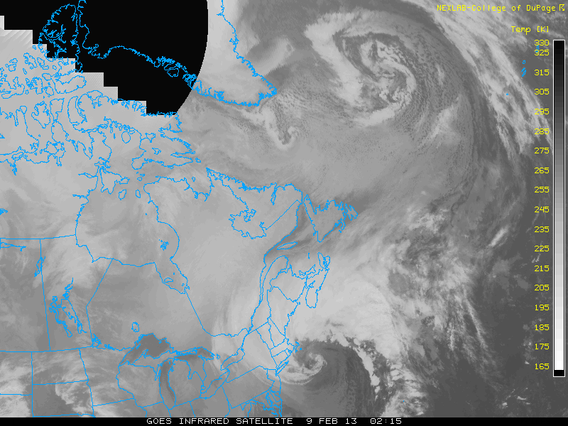
Additionally, here are a few amazing infrared, satellite, and water vapor images that make the Blizzard of 2013 look a lot more like a hurricane than a winter storm.


The snowfall rates during these hours after must have been conservatively four inches per hour, and probably closer to six or more. I thought around 2AM I had a conservative 32 inches of snow down as the heaviest echoes moved away from me. Heavy to moderate and then light snow would continue for several more hours putting down at least several more inches. Even measuring the storm was obviously a problem because of the fact the wind was blowing it all over the place. I used a variety of techniques and averages to come to my totals as it went along, but during the morning after, from additional hours of wind and compaction, the totals did not reflect what we truly received.

Here is the final surface map for 7AM on Saturday morning as the historic Blizzard of 2013 moved away from New England with its banding lingering overhead.


As I considered total accumulations more in the days after the storm with a clearer and rested mind I have come to the conclusion that those of us in the central Connecticut strip seen in the radar images above likely all received at least 36 inches with many spots hitting over 40. This is not a belief shared by a lot of people outside those areas. But both professionals and amateurs like me who lived in these areas and stared at the radar and watched out their windows all night think it is. Measuring during the storm and comparing those totals to totals at dawn it seems utterly illogical that so little snow (an inch or two or less) could have fallen from around 1-2AM to the dawn when we saw heavy to moderate and then light snow lingering for hours. I said I had around 32 inches at 2AM and in open areas Saturday morning the best I could come up with was around 31 or 32 inches. I noted a lamp post here in the middle of an open lawn around 2:30AM that had a lower level of snow surrounding it several hours later. When the snow melts I will eagerly measure it from the ground to around the point I saw the snow reach and add in some more creative math to see where I think I really ended up. No one will ever be sure how much fell, but it was an astonishing amount.

One event cannot be classified as evidence of climate change or global warming, and this sort of storm can be expected every 100-200 years here. Nevertheless, I keep writing that in this blog every few months, don't I? Our world is changing and we are all witnesses. At least now the vernal pools have a better chance of being full of water this spring...


Scott Kruitbosch
Conservation Technician

Images via the National Weather Service, Wunderground, College of DuPage, the Pennslyvania State University, and the National Oceanic and Atmospheric Administration